|
First National Meeting on Remote Sensing and Geographic Information Systems of Puerto Rico
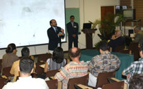
The CoHemis Center organized on May 27, 2003 in Mayaguez the "First National Meeting on Remote Sensing and Geographic
Information Systems of Puerto Rico". This meeting was a first step in the creation of a plan and a working group which
encompasses the development and the coordination of efforts and initiatives and promotes the export of services in this
field.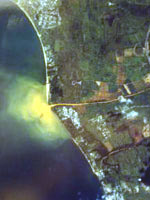
CoHemis Director Dr. Fernando Gilbes, a specialist in applications of remote sensing to the study of water bodies,
presided the event. According to him, it was the growing interest in Remote Sensing and Geographic Information Systems
(GIS) and the existing dispersion with respect to both of the affiliation of their users and their professional fields,
that motivated the organization of this encounter.
The meeting's assistants interacted with presenters from UPRM research centers such as the Tropical Center for Earth and
Space Studies (TCESS) and PaSCoR, as well as government agencies such as the Information Center for the Evaluation of Land
of the Puerto Rico Planning Board and the Information Transfer Center of the Puerto Rico Highway Authority. There were also
presentations on satellite images as instruments of remote sensing, the use and value of digital teledetection for social
sciences and the application of a GIS for city ordenacion territorial. Another presentation dealt with the work conducted
by the Ordenación Territorial Office of the City of Ponce and the Municipality of Bayamón for the US Geologic Survey in the
identification of flood-prone areas.
 Other participants included Dr. Angel D. Cruz, from the Geography Departament of the Río Piedras Campus of the University
of Puerto Rico; surveyor Renán López de Azúa, president of RLDA Geo-Métrica, a company that conducts studies of
photogrammetry, hidrography, topography and the localization of underground infrastructure, among others. Carlos
Paniagua and Pedro Gelabert, both from the US Environmental Protection Agency (EPA), explained the role of the agency
in the UN's Environment Program (UNEP), through which a demonstration program on a GIS which encompasses the northwestern
Caribbean and includes the Dominican Republic, Puerto Rico and the US and British Vírgin Islands.
Other participants included Dr. Angel D. Cruz, from the Geography Departament of the Río Piedras Campus of the University
of Puerto Rico; surveyor Renán López de Azúa, president of RLDA Geo-Métrica, a company that conducts studies of
photogrammetry, hidrography, topography and the localization of underground infrastructure, among others. Carlos
Paniagua and Pedro Gelabert, both from the US Environmental Protection Agency (EPA), explained the role of the agency
in the UN's Environment Program (UNEP), through which a demonstration program on a GIS which encompasses the northwestern
Caribbean and includes the Dominican Republic, Puerto Rico and the US and British Vírgin Islands.
Doctor Gilbes trusts that this meeting has set the basis for the realization of similar subsequent events in which more
enphasis to the importance of remote sensing and GIS for fields as different and as important as health, agriculture and
planning. For this purpose, CoHemis has been providing follow-up by means of an internet group for discussing ideas and
announcing events in the field.
Photo Gallery
|